

What are the parameters of reconnaissance cameras developed in Poland for satellite observations? What can these types of instruments identify on the battlefield?
In recent weeks, the Russian military offensive in Ukraine has clearly demonstrated how important optical reconnaissance using observation satellites is. Thanks to the access to the images of the Maxar constellation and European Copernicus, the whole western world can follow the changes on the front line and the groupings of Russian troops. For several years, Poland has been financing research and development projects aimed at developing platforms and instruments to observe such events. What are the parameters of the developed reconnaissance cameras as of the moment, how do they differ from each other and what could they see in the area of today’s battles? We answer these questions in a brief analysis.
What can be seen from orbit?
The Russian aggression against Ukraine has shown very precisely what kinds of satellite reconnaissance is important for the battlefield. In this conflict, the military operation involving armored vehicles, tanks and other wheeled equipment was observed mainly on the road infrastructure. Images monitoring road network, allow to assess both tactical capabilities, deployment and help in estimation of numbers of enemy troops. This also implies the need for increased imaging resolution, which translates into optical instruments with apertures of at least (diameter) on the order of 150-250 mm, assuming imaging from an orbit of 350-550 km. The spatial resolution of such a telescope is between 2 and 0.9 m/pix.
Another example of objects that are currently closely monitored on the territory of Ukraine and Russia are the effects of military actions, such as fires, destroyed infrastructure or damage to civilian objects (schools, hospitals and stores). The possibility of monitoring such objects gives partly tactical information, but also important signals to the public, related to the type of aggression used by the enemy, including aggression against civilians. This is particularly important in informing on potential actions that violate international law and war treaties. In this case, the optics have lower resolution requirements and such imagery can be obtained using apertures as low as 100 mm. Resolution in this case is between 2 and 6 m/pix.
The last type of imagery separated for the purpose of this analysis are camouflaged objects, very often in forest areas, which can be of great tactical importance and are therefore actively concealed by the enemy. It is in vain to look for pictures showing such objects in mass media, because to obtain them the most sensitive imaging systems of the highest available resolution are used, and very often they are classified, due to secret technical solutions. Telescopes allowing such imaging have apertures over 300 mm, and in unofficial analyses one can find information about satellites equipped in the USA, the size of Hubble Space Telescope, but adapted to satellite reconnaissance. We are talking about resolutions below 0.9 m/pix, and in a post declassified a few years ago on Donald Trump’s Twitter account, the public could see a satellite photo of an Iranian missile launcher with a resolution as low as 0.15 m/pix. It is worth noting here that no commercial entity (so far) on Earth allows imaging at such resolution.
It is worth noting that most objects are observable in the visible band. The infrared band, especially SWIR and thermal, although more difficult to image, provide the opportunity to visualize higher temperature objects such as engines, fires, and operating machinery. It is worth noting that unlike SAR imaging techniques, almost any optical instrument requires good weather.
Conflict an issue even for industry leaders
In recent weeks, numerous images and data from satellites, including those of Maxar, have been released to the public. This American entity has the most advanced satellite constellation called WorldView Legion. It consists of four satellite constructions connected into a network of 90 satellites. With declared resolutions of up to 31 cm/pix, it is possible to realize almost all key tactical imaging in Ukraine, Russia and Belarus. In particular, the world’s attention has been focused on the 60-kilometer-long traffic jam of Russian tanks and combat vehicles on their way to Kiev and on the groupings of troops at the borders of Ukraine even before the conflict.
It is worth noting that during the first 10 days of the invasion, the Maxar constellation was used to its limits for several reasons. First of all, a constellation with a relatively small number of satellites does not provide a small revisit time, which combined with unfavorable cloud cover resulted in a relatively small number of imaging opportunities. The images released to the public often show a large perspective distortion due to observation at a very large angle of deviation from nadir (i.e., the direction of observation perpendicular to the earth), which is very detrimental to the quality of the imagery and its resolution.
Currently, no Polish or even European entity is in the middle of a publicly known research process to obtain optical imaging with resolutions similar to Maxar’s, but there are a large number of entities developing instruments capable of 1 m/pix level observations.
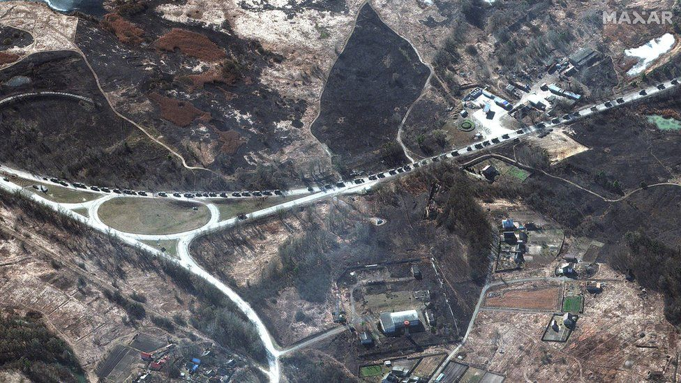
MAXAR photo tilted hard off the nadir
Polish attempts at satellite imaging so far
When analyzing Polish satellite and aerial reconnaissance capabilities, it is worth starting with the current performance of entities operating in this area. Most probably, the first Polish satellite to provide satellite images of the Earth is PW-Sat2. The images obtained from a camera developed for a completely different scientific purpose, in December 2018, show our planet in a very wide field of view. It is impossible to determine the spatial resolution of the image, but estimates point rather to whole kilometers per pixel. Apart from its historical value, imaging of this type carries no scientific or tactical value, but of course it must be remembered that this camera was not placed on a satellite for any of these purposes.

PWSat-2 First Polish photo of Earth from space
After the success of the PWSat-2 satellite, an attempt to image the Earth with the Swiatowid satellite from the SatRevolution laboratories should be mentioned. Unfortunately, the obtained images did not meet the expectations of the mission, but constituted an important technical and imaging step for the company. It is estimated that Swiatowid has provided 90 m/pix (before the flight the company declared < 3 m/pix in the final stages of the mission). Images of this type still do not provide tactical value, but in extreme cases could provide information on the level of damage to cities and infrastructure.
One of the decoded images from the Swiatowid satellite
A Polish entity focused on designing and supplying optical instruments for satellites, Scanway has recently reached an important milestone in high-altitude imaging. The company has been working for several years in consortia with WAT, Creotech Instruments and CBK PAN, among others, related to orbital imaging satellites. The nearest mission, named STAR VIBE, assumes sending in a Polish-German satellite, a telescope produced by Scanway with an aperture of 50 mm. It is a demonstrator of imaging technology, but for development purposes the company last week sent a stratospheric mission with this lightweight telescope pointed at nadir. The resulting 37 cm/pix resolution images can differentiate between ground targets, both military and civilian. The analysis is the first to publish images obtained in the mission of 2.03 over Lower Silesia. The images were obtained from an altitude of nearly 30 km, i.e. from the stratosphere ceiling. It is not difficult to imagine the value of such images in the current Russian-Ukrainian conflict. Scanway is currently working on adapting the optics and image acquisition electronics for tactical missions.
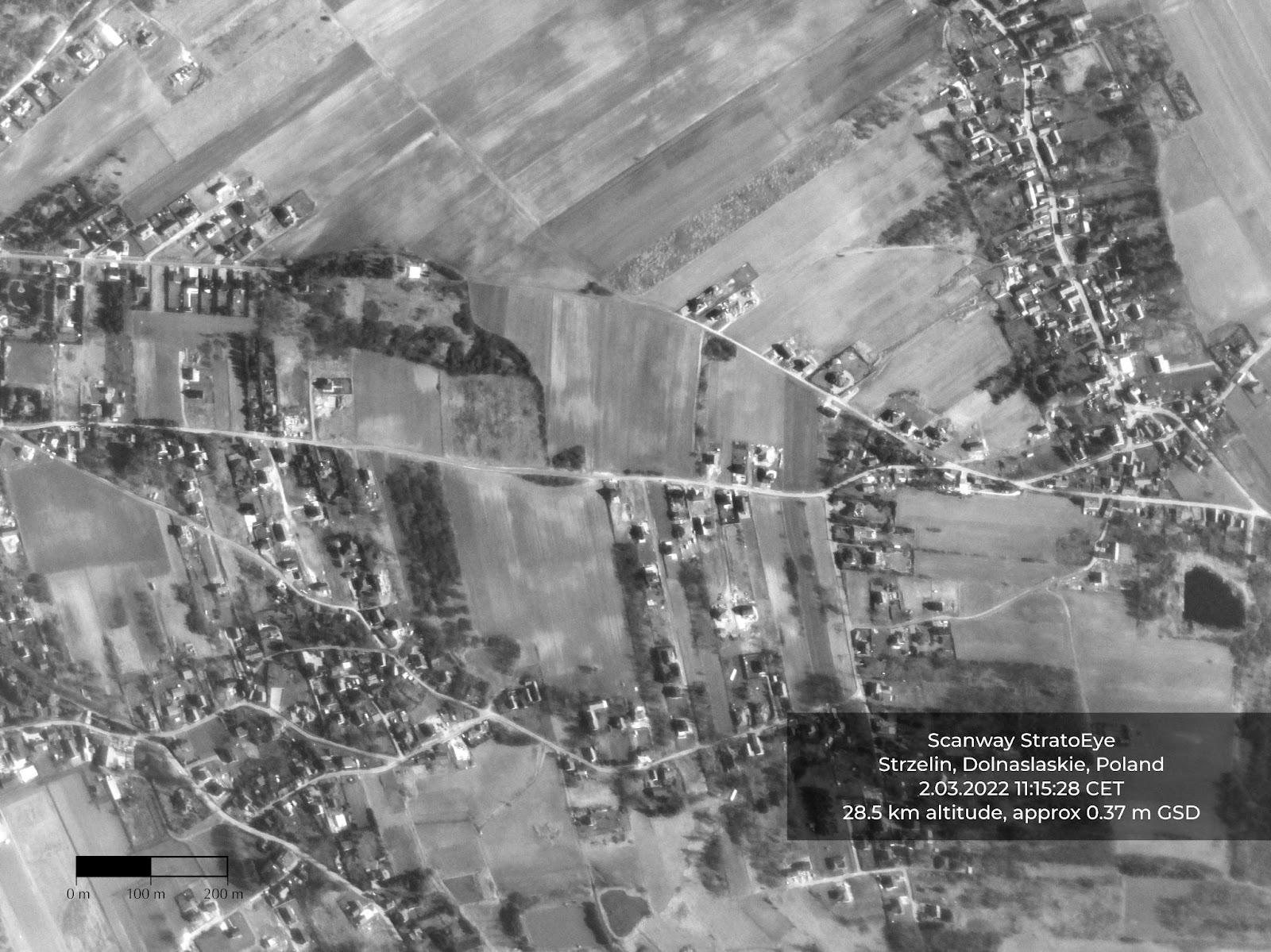
Scanway’s image acquired on mission 02.03.22 over Lower Silesia

Scanway’s image acquired on mission 02.03.22 over Lower Silesia
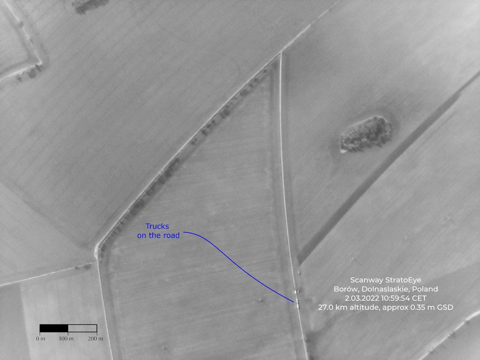
Scanway’s image acquired on mission 02.03.22 over Lower Silesia
Ongoing projects of Polish entities
In Poland, over the last few years, a number of different types of projects have begun that are related to Earth observation. The group of companies that conduct these projects includes KPLabs, Scanway, CBK PAN and SatRevolution.
KPLabs, a Gliwice-based company, is developing its CubeSat 6U-class nanosatellite (Intuition-1), whose main purpose is to process hyperspectral data on board a proprietary supercomputer based on FPGA modules. Of course, the optical system is also designed by the Gliwice-based company. The declared imaging quality parameters are scenes of 40 x 40 km size and 25 m/pix resolution. The satellite with this imaging payload is expected to be fully functional in orbit in 2023.
Several internal and external projects are currently running at Scanway. At the core of the company’s telescope competence is the ScanSAT project, which was co-financed by NCBiR. It ended with a prototype of an imaging device. On the basis of this project a number of other activities were developed – telescopes for EagleEye, PIAST and STAR VIBE missions.
EagleEye is a consortium project realized within NCBiR funds together with Creotech Instruments and CBK PAN. Within this project, a fully-fledged microsatellite with imaging resolution of 1 m/pix is being created. This is the value which allows us to offer such a solution to the world’s entities. Of course, the correlation of resolution with the size of the picture means that the EagleEye mission imaging will not be able to capture e.g. the whole city of Wroclaw. It is worth remembering that in case of Maxar satellites it is the same.
As a part of the PIAST project (also co-financed by NBCiR), a constellation of microsatellites for military use is being developed. Imaging devices developed within this project are both by Scanway and CBK PAN. Their goal is to achieve resolutions of 5 m/pix and less. Since this is a project created in close cooperation with the end customer, results tailored to actual needs can be expected.
Scanway’s latest project is the STAR VIBE mission, which will test an on-orbit telescope capable of observing at a resolution of 26 m/pix and an imaging width of 106 km. This is a project that will validate the design and integration processes of optical telescopes and will allow for quality assurance of solutions on the EagleEye and PIAST missions.
SatRevolution is a commercial entity that specializes in nanosatellite platforms and the creation of observation payloads. So far, a number of their satellites with various telescopes have been sent into orbit, while images have only been shown from the Swiatowid mission, which was designed to allow imaging with a resolution of approx. 3-5 m/pix. Other projects the company is currently working on are the Stork platform, which provides a resolution of 5.8 m/pix, and REC, which is intended to be a constellation with a resolution of 50 cm/pix. Several satellites based on the Stork platform have already been launched, but the company has not yet published the first images from these missions.
A review of the Polish market shows that there are in fact several interesting initiatives that can provide valuable imagery for a military customer if needed, and in the vast majority will fulfill all the requirements for quality imagery for a civilian customer.
What capabilities might Polish EO satellites have?
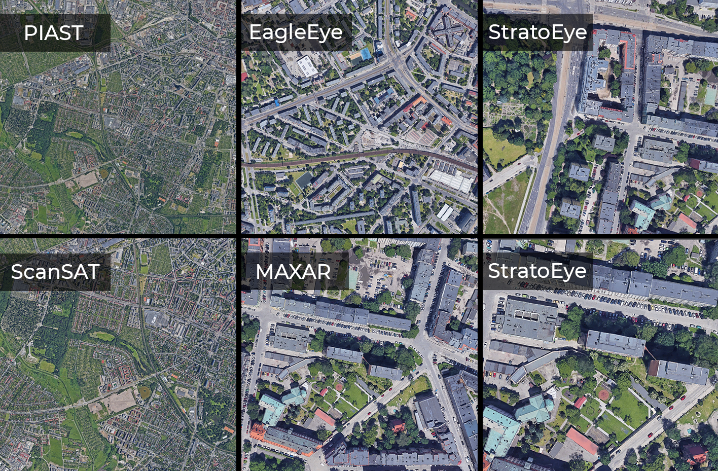
In order to show the potential of optical instruments of the Polish space industry, a comparison of telescope resolutions obtained and declared by companies was made. For the sake of visual clarity of the analysis, resolutions of 10 m/pix and less were taken into account, since they represent the greatest value in the context of satellite and intelligence imaging.
Therefore, the resolutions of telescopes that are part of: the future Polish nanosatellite constellation PIAST, potentially the first Polish Earth observation microsatellite EagleEye, the prototype ScanSAT Earth observation nanosatellite, and stratospheric missions under the title StratoEye were analyzed. For the best visual comparison of resolution, the resolution of the Maxar telescopes was taken as the benchmark.
It was assumed that we would ultimately get a 1000×1000 pix image from each of the telescopes. The graphic below shows in a simplified way what size areas we would theoretically be able to see in a 1000×1000 pix image at the same resolution.

It is worth adding that the analysis compares resolutions only in a very relative way due to the fact that each satellite mission is on a different orbit, i.e. at a different distance (altitude) from the Earth surface. Constellation PIAST, the telescope’s resolution of which is to reach 5 m/pix, will be placed on the 500 km orbit. Theoretically, the ScanSAT nanosatellite would be placed on the same orbit to achieve the assumed resolution of 4 m/pix. In the case of the EagleEye microsatellite, the resolution is to reach 1m/pix in a 350 km orbit. As for stratospheric flights, the achieved resolution is 0.37 m/pix at 30 km altitude, and 0.2 m/pix at 10 km altitude.
Summary
Poland’s history, systemic transformation, and the problems of a country catching up to its Western counterparts have not been conducive to the rapid development of the space industry. Joining the European Space Agency in 2012 opened new perspectives for the fledgling space industry. In 2017, the first major commercial initiatives to develop Earth observation payloads were launched, and as you can see, this process is not yet complete. The upcoming observation missions will fly this year and next year (STAR VIBE and EagleEye, respectively) and should provide the first satisfactory results – unless SatRevolution shows its imaging before then.
Of course, reconnaissance from orbit is not the only way to acquire satellite imagery. Drones can be used for these purposes, but in the case of airspace dominance, this can be a risky and expensive maneuver. The Ukrainian conflict shows that drones are used combatively, and local reconnaissance is conducted from commercial drone platforms. In the future, it will probably be possible to use so-called HAPS, which are aerial platforms capable of circling over a given area from an altitude of more than 20 kilometers, but unless their legal status is equated with satellites and they are “untouchable,” it will not be possible to use them in an armed conflict because of the real risk of being shot down.
As you can see, the process of creating the capability to design imaging payloads is long, while it can be significantly accelerated. It is important to realize that the lack of a National Space Program and state support in this area means that companies must commit their own resources – which necessarily slows down the process. With central support, it is possible to achieve the same results much faster, as the examples of Western countries show.
This reality was in effect until the outbreak of war in Ukraine. This situation shows us how important imagery reconnaissance is. The amount of reconnaissance data, presumably provided by NATO and individual states to the Ukrainian side, allows our neighbors to conduct effective defenses, slow the pace of Russian aggression, and precisely destroy military equipment. Without such systems, this conflict could look very different, demonstrating that satellite projects aimed at Earth imaging should be strategic state-level activities. Without the rapid development of funds for a Polish Earth observation constellation, in the event of a conflict that until recently seemed straight out of science fiction, we as a state could be in a very problematic situation that will cost human lives.


